 GeoMIS.Th
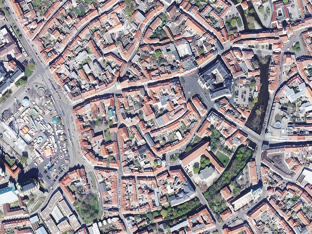
Bildbasiertes Digitales Oberflächenmodell - bDOM
Das digitale Oberflächenmodell (bDOM) ist eine auf ein regelmäßiges Raster reduzierte Punktwolke, in der Höhen und Formen der Erdoberfläche inklusive seiner Bauwerke und Vegetation abgebildet sind. bDOM-Daten bilden die Situation zum Zeitpunkt der Erfassung, also des Flugtages, ab. Variieren die Erfassungszeitpunkte, können z.B. Gewässerpegelstände oder Oberflächenbewuchs innerhalb eines Projektgebiets variieren. Die Punktgitterweite des aktuellen DOM-Produkts beträgt 20 cm.
Simple
- Alternativtitel
-
Digitale Oberflächenmodelle
- Datumsangaben (Publikation)
- 2024-01-01
- Identifikator
- https://registry.gdi-de.org/id/de.th.csw/1c2a4b6b-7938-4f42-8e24-2d48ce4fe594
- Präsentationsform
- Digitales Bild
- Bearbeitungsstatus
- Kontinuierliche Aktualisierung
+49 (361) 57-2176 450
https://tlbg.thueringen.de/
- Überarbeitungsintervall
- Kontinuierlich
- Datenpflegebereich
- Datenbestand
- Keywords
-
-
Erdoberfläche
-
Befliegung
-
Geoproxy
-
Orthophoto
-
Luftbild
-
AdVMIS
-
GOVE
-
opendata
-
bdom
-
-
GEMET - INSPIRE themes, version 1.0
-
-
Orthofotografie
-
-
Spatial scope
-
-
Regional
-
- Anwendungseinschränkungen
-
Nutzungsbedingungen: Für diesen Datensatz gelten die Nutzungsbedingungen nach der Datenlizenz Deutschland-Namensnennung, zurzeit in der Version 2.0 ( https://www.govdata.de/dl-de/by-2-0) unter Verwendung des Quellvermerkes "© GDI-Th".
- Zugriffseinschränkungen
- Benutzerdefinierte Einschränkungen
- Nutzungseinschränkungen
- Benutzerdefinierte Einschränkungen
- Andere Einschränkungen
-
Nutzungsbedingungen: Datenlizenz Deutschland-Namensnennung 2.0 in JSON Syntax
- Andere Einschränkungen
-
{"id": "dl-by-de/2.0", "name": "Datenlizenz Deutschland Namensnennung 2.0", "url": " https://www.govdata.de/dl-de/by-2-0 ", "quelle": "© GDI-Th"}
- Räumliche Darstellungsart
- Raster, Gitter
- Distanz
- 0.2 m
- Sprache
- Deutsch
- Thematik
-
- Planungsunterlagen, Kataster
- Oberflächenbeschreibung
- Beschreibung
-
Thüringen
))
- Identifikator des Referenzsystems
- urn:ogc:def:crs:EPSG / EPSG:25832
- Abgabeformat
-
-
TIFF
(
8 bit, 24 bit
)
-
TIFF
(
8 bit, 24 bit
)
+49 361 57-4176 759
- Online
- Informationen des TLBG zu Digitalen Landschaftsmodellen ( WWW:LINK-1.0-http--link )
- Online
-
ThürVwKostOVerm
(
WWW:LINK-1.0-http--link
)
Kostenordnung (ThürVwKostOVerm)
- Online
- AGNB ( WWW:LINK-1.0-http--link )
- Bezugsebene
- Datenbestand
Konformitätsergebnis
- Alternativtitel
-
INSPIRE Specification - Orthofotografie
- Datumsangaben (Publikation)
- 2013-12-10
- Identifikator
- Orthofotografie
- Präsentationsform
- Digitales Dokument
- Erklärung
-
INSPIRE Annex-Thema
- Bestanden
- Ja
Konformitätsergebnis
- Datumsangaben (Publikation)
- 2010-12-08
- Erklärung
-
Getestet mit der GDI - DE Testsuite
- Bestanden
- Nein
Konformitätsergebnis
- Datumsangaben (Publikation)
- 2008-12-03
- Erklärung
-
Getestet mit der GDI - DE Testsuite
- Bestanden
- Ja
- Erläuterung
-
Ein Luftbild wird differenziell entzerrt und auf ein orthogonales Koordinatensystem transformiert.
- Metadatensatzidentifikator
- 1c2a4b6b-7938-4f42-8e24-2d48ce4fe594 XML
- Sprache
- Deutsch
- Zeichensatz
- Utf8
- Hierarchieebene
- Datenbestand
- Datum
- 2026-01-08T14:10:58
- Bezeichnung des Metadatenstandards
-
ISO19115
- Version des Metadatenstandards
-
2003/Cor.1:2006
+49 361 57-4176 799
https://tlbg.thueringen.de/