 GeoMIS.Th
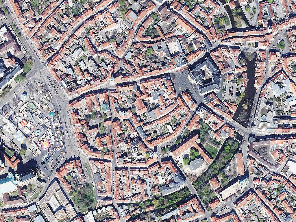
Digitale Orthophotos
Das Orthophoto ist ein entzerrtes und georeferenziertes Luftbild von hoher Genauigkeit und Aktualität. Es eignet sich daher sehr gut zur Erfassung und Aktualisierung von Datenbeständen geographischer Informationssysteme, zu Planungszwecken, geometrisch genauen Ausmessungen u.v.m. Da es auf Landeskoordinaten bezogen ist, kann es auch mit anderen Datenbeständen, z.B. der digitalen topographischen Karte, dem digitalen Landschaftsmodell oder benutzereigenen Daten kombiniert werden.Die digitalen Orthophotos werden mit einer Bodenauflösung von 0,20 m berechnet. Ein Orthophoto deckt eine Landschaftsfläche von 1 km x 1 km ab. Befliegungen erfolgen seit 1994. Seit 2014 erfolgt der Bildflug im 2-Jahres Zyklus.
Simple
- Alternativtitel
-
Digitale Orthophotos
- Datumsangaben (Publikation)
- 2015-04-01
- Identifikator
- https://registry.gdi-de.org/id/de.th.csw/3940ce6d-a2fc-44cf-9b30-916f999750ae
- Präsentationsform
- Digitales Bild
- Bearbeitungsstatus
- Kontinuierliche Aktualisierung
+49 (361) 57-2176 450
https://tlbg.thueringen.de/
- Überarbeitungsintervall
- Kontinuierlich
- Datenpflegebereich
- Datenbestand
- Keywords
-
-
Erdoberfläche
-
Befliegung
-
Geoproxy
-
Orthophoto
-
Luftbild
-
AdVMIS
-
GOVE
-
opendata
-
DOP
-
inspireidentifiziert
-
dop
-
-
GEMET - INSPIRE themes, version 1.0
-
-
Orthofotografie
-
-
Spatial scope
-
-
Regional
-
-
High-value dataset categories
-
-
Erdbeobachtung und Umwelt
-
- Zugriffseinschränkungen
- Benutzerdefinierte Einschränkungen
- Andere Einschränkungen
- Es gelten keine Zugriffsbeschränkungen
- Nutzungseinschränkungen
- Benutzerdefinierte Einschränkungen
- Andere Einschränkungen
-
Es gelten die Lizenzbedingungen „Datenlizenz Deutschland - Namensnennung - Version 2.0“ bzw. „dl-de/by-2-0” ( https://www.govdata.de/dl-de/by-2-0) mit den dort geforderten Angaben zum Quellenvermerk. Als Rechteinhaber und Bereitsteller ist die Datenhaltende Stelle, sowie das Jahr des Datenbezugs in Klammern anzugeben. Beispiel für Quellenvermerk: GDI-Th (2021) Datenlizenz Deutschland - Namensnennung - Version 2.0 (www.govdata.de/dl-de/by-2-0).
- Andere Einschränkungen
-
{
"id": "dl-by-de/2.0",
"name": "Datenlizenz Deutschland Namensnennung 2.0",
"url": " https://www.govdata.de/dl-de/by-2-0",
"quelle": "© GDI-Th"
}
- Räumliche Darstellungsart
- Raster, Gitter
- Distanz
- 0.2 m
- Sprache
- Deutsch
- Thematik
-
- Planungsunterlagen, Kataster
- Oberflächenbeschreibung
- Beschreibung
-
Thüringen
))
- Identifikator des Referenzsystems
- http://www.opengis.net/def/crs/EPSG/0/25832
- Abgabeformat
-
-
TIFF
(
8 bit, 24 bit
)
-
TIFF
(
8 bit, 24 bit
)
+49 361 57-4176 759
- Online
- Informationen des TLBG zu Luftbilder & Orthophotos ( WWW:LINK-1.0-http--link )
- Online
-
ThürVwKostOVerm
(
WWW:LINK-1.0-http--link
)
Kostenordnung (ThürVwKostOVerm)
- Online
- AGNB ( WWW:LINK-1.0-http--link )
- Online
-
Download Luftbilder und Orthophotos
(
WWW:LINK-1.0-http--download
)
Downloadbereich auf Geoportal Thüringen
- Online
- GDI-TH-DOP, WMS ( OGC:WMS-http-get-map )
- Bezugsebene
- Datenbestand
Konformitätsergebnis
- Alternativtitel
-
INSPIRE Specification - Orthofotografie
- Datumsangaben (Publikation)
- 2013-12-10
- Identifikator
- Orthofotografie
- Präsentationsform
- Digitales Dokument
- Erklärung
-
INSPIRE Annex-Thema
- Bestanden
- Ja
Konformitätsergebnis
- Datumsangaben (Publikation)
- 2010-12-08
- Erklärung
-
Getestet mit der GDI - DE Testsuite
- Bestanden
- Nein
Konformitätsergebnis
- Datumsangaben (Publikation)
- 2008-12-03
- Erklärung
-
Getestet mit der GDI - DE Testsuite
- Bestanden
- Ja
- Erläuterung
-
Ein Luftbild wird differenziell entzerrt und auf ein orthogonales Koordinatensystem transformiert.
- Metadatensatzidentifikator
- 3940ce6d-a2fc-44cf-9b30-916f999750ae XML
- Sprache
- Deutsch
- Zeichensatz
- Utf8
- Hierarchieebene
- Datenbestand
- Datum
- 2025-09-02T10:49:59
- Bezeichnung des Metadatenstandards
-
ISO19115
- Version des Metadatenstandards
-
2003/Cor.1:2006
+49 361 57-4176 799
https://tlbg.thueringen.de/